Russian Geology and Geophysics Vol. 45, No. 5, pp. 616-625, 2004
Geologiya i Geofizika UDC 550.361
LAKE ISSYK KUL’ (TIEN SHAN): UNUSUALLY LOW HEAT FLOW IN AN ACTIVE INTERMONTANE BASIN P. Vermeesch1, J. Poort2,1, A.D. Duchkov3, J. Klerkx2, and M. De Batist1 1
Renard Centre of Marine Geology, University of Ghent, Krijgslaan 281 S8, B-9000 Ghent, Belgium 2 Department of Geology and Mineralogy, Royal Museum for Central Africa, Leuvensesteenweg 13, B-3080 Tervuren, Belgium 3 Institute of Geophysics, Siberian Branch of the RAS, 3 prosp. Akad. Koptyuga, Novosibirsk, 630090, Russia
New geothermal data are presented for Lake Issyk Kul’, a mountain lake in the northern Tien Shan, Central Asia. With 40 successful measurements done, the average heat flow is 48.3 mW/m2. This is 10 to 20 mW/m2 lower than estimates from previous surveys. Data from boreholes on the shores of the lake revealed an average heat flow of 54 mW/m2. All these values are remarkably low for an actively deforming area such as the Tien Shan. Two qualitative geodynamical models are suggested to explain these observations. If there is crustal thickening beneath Issyk Kul’, the low heat flow can only be explained in a transient mode, with “sawtooth geotherm”. In equilibrium conditions, low heat flow implies that there is little or no crustal thickening under the basin. This feature could be the result of lithospheric folding, as may occur throughout Central Asia. Heat flow, geothermal gradients, geodynamical models, Lake Issyk Kul’, Tien Shan, Kyrghyzstan
INTRODUCTION The intermontane Issyk Kul’ basin is located in the northern Tien Shan, one of the world’s major intracontinental mountain ranges. The Tien Shan extends from the Kyzyl Kum desert in the west to the Gobi desert and Mongolia in the east. The active deformation of the Tien Shan can account for approximately 20 mm of accumulated shortening per year [1]. Several major strike-slip faults as the Talas-Fergana fault have been active in the Cenozoic. Thus the current tectonic context is one of transpression. The Cenozoic deformation is commonly attributed to the indentation of Central Asia by India [2]. The mountain range can be considered as a complex zone of weakness “squeezed out” between the Tarim basin in the south and the Kazakh Shield in the north. The Tien Shan consists of a number of foldbelts of E-W direction, perpendicular to the direction of maximum compression. These belts are separated by relatively flat intermontane basins such as: Naryn basin, Fergana basin, and Issyk Kul’ basin (Fig. 1). Located in Eastern Kyrghyzstan at an altitude of 1606 m, Lake Issyk Kul’ is characterized by a deep (668 m) central basin with a flat bottom, which occupies 25% of the lake area (Fig. 2). In the eastern part of this deep basin exists a ridge-like structure, which is the morphological expression of an active anticlinal fold, as shown by reflection seismic profiles [3]. Lake Issyk Kul’ is thermally stratified. This was confirmed by 11 CTD profiles which were recorded throughout the lake in the framework of this research project. At the deepest parts of the lake a constant temperature of 4.177 °C was measured. Owing to these quiet conditions, Issyk Kul’ is particularly appropriate for marine-type heat-flow measurements as a new input in the discussion of intracontinental deformation in general and in the Tien Shan in particular. In this paper we present an extensive new heat-flow dataset from the deep lake area. We will show that in the deep basin a uniform and low heat flow is observed, except for several disturbed thermal gradients on an anticlinal ridge in the southeastern part. This background heat flow puts ©2004 UIGGM, SIBERIAN BRANCH OF THE RAS
574
Russian Geology and Geophysics
Vol. 45, No. 5
Fig. 1. Location of the Tien Shan mountain ranges in the active Central Asian deformation zone. Inset shows location of Issyk Kul’ basin within Tien Shan. Shaded relief map from USGS files.
new constraints on geodynamical models of the Issyk Kul’ region. We will discuss two geodynamical models that explain the new thermal data in the framework of present knowledge on the crustal and lithospheric structure of the Tien Shan and other orogenic systems. PREVIOUS GEOTHERMAL STUDIES Heat-flow estimates in boreholes surrounding the lake, were made in general by Shvartsman et al. [4–6]. Boreholes have been drilled to depths of 200 up to 4900 m, some of them reaching the Paleozoic basement beneath the Cenozoic sediments. Thermal conductivity (λ) of the Cenozoic rocks and the basement rocks average respectively 2.05 and 2.50 W/(m⋅K). The heat-flow estimates are presented with an accuracy of 15 to 20%, and corrections were made for relief, sedimentation and Quaternary glaciations. The mean heat flow on-shore is 54.4 mW/m2, ranging from 14 to 78 mW/m2 (Table 1). Within the limits of the lake, geothermal measurements were carried out by Soviet scientists between 1969 and 1972 [5, 7]. The thermal conductivity of the sediments and the mean geothermal gradient in the sediment layer of 1–1.5 m were measured by means of an autonomous thermal probe at water depths of 115 to 660 m. Stations were located along three N-S profiles. Only the central one crossed the flat deep basin, whereas the other two were situated along the slopes (Fig. 2). The heat-flow pattern shows rather stable values on the flat basin floor of about 60–70 mW/m2 (Table 2), while along the slopes large variability exists λ = 0.9−1.4 W/(m⋅K).
575
Russian Geology and Geophysics
Vol. 45, No. 5
Fig. 2. Morphology of Issyk Kul’ basin (De Batist et al., 2002), and location of on-shore boreholes and off-shore marine-type thermal stations in Lake Issyk Kul’. Inset shows a contour map of the heat flow on the flat bottom of Lake Issyk Kul’ based on the new thermal data.
NEW HEAT-FLOW MEASUREMENTS During international expedition in 1998 year a total number of 49 heat-flow measurements were carried out using GEOS-T [8], Russian “violin bow”-design geothermal probe with online temperature registration at 4 depth intervals. The efforts were concentrated on the lake’s central basin where quiet sedimentation conditions and thermal stratification of the water body allow the surface heat flow to approximate the background heat-flow value. The central Issyk Kul’ basin has quite a stable relief, except for an anticlinal ridge, which is allegedly associated with tectonic activity [3, 9] and thus forms a potential site for local heat-flow anomalies. At forty stations, satisfactory penetration conditions were encountered for the probe to register thermal gradients at depth intervals of 0.5 m to an accumulated depth of 2 m. Thirty-one stations were collected on the anticlinal ridge, the other nine were placed in the flat part of the central basin (Fig. 2). The ridge area generally featured the best penetration conditions. In the central basin, four stations only had 3/4 penetration (1.5 m depth) because the sediments there were more compact. Sediments near the lakeshore were mostly coarse and too hard to penetrate. The average value of all 40 gradient measurements is 38.8 °C/km, with a standard deviation of 11.1 °C/km 576
Russian Geology and Geophysics
Vol. 45, No. 5
Table 1 Summary of the Old Russian Data: Land Locations [4, 6], and Off-Shore Locations in the Central Basin [7, 6] Coordinates
Heat flow (mW/m2)
Station East
North
1
42.65
77.50
31
2
42.65
77.08
79
3
42.65
77.08
74
4
42.81
78.23
64
5
42.81
78.23
49
6
42.81
78.23
55
7
42.81
78.23
43
8
42.42
78.08
47
9
42.41
78.05
14
10
42.55
78.27
43
11
42.67
77.25
47
12
42.49
76.13
60
13
42.46
76.23
62
14
42.59
78.40
55
15
42.40
77.89
55
16
42.40
77.89
43
17
42.62
76.97
70
18
42.67
78.41
47
19
42.67
78.45
37
20
42.40
78.13
37
21
42.27
76.60
78
22
42.48
76.42
78
23
42.56
76.66
70
24
42.15
77.55
47
25
42.65
77.18
76
26
42.47
77.08
88
27
42.42
77.07
67
28
42.38
77.08
71
29
42.35
77.07
59
30
42.30
77.07
59
Note. 1–25 — land locations (λ = 2.05−2.50 W/(m⋅K); 26–30 — off-shore locations (λ = 0.9−1.4 W/(m⋅K).
and standard error of 3.5 °C/km (Table 2). The gradient varied between 24 °C/km and 62 °C/km. The highest values were obtained on the ridge, but no strong anomalous features could be delimited. The nine stations on the flat area (off the ridge) give an approximately identical average gradient of 38.0 °C/km. A contour map of the geothermal gradient based on the new data is presented in Figure 2. At five stations, gravity cores were taken for thermal conductivity determinations by means of a needle probe. A constant value of λ = 1.1 W/m⋅K was measured. 577
Russian Geology and Geophysics
Vol. 45, No. 5
Table 2 List of All New Thermal Gradient and Heat-Flow Values on the Bottom of Lake Issyk Kul’ Coordinates
East
North
Thermal gradient (°C/km)
77.41 77.39 77.38 77.39 77.42 77.36 77.35 77.34 77.38 77.42 77.42 77.44 77.44 77.42 77.38 77.43 77.36 77.38 77.38 77.40 77.47 77.25 77.25 77.40 77.25 77.31 77.32 77.32 77.32 77.25 77.28 77.29 77.31 77.26 77.43 77.07 77.07 77.07 77.06 77.06
42.33 42.34 42.35 42.34 42.31 42.30 42.31 42.33 42.29 42.36 42.35 42.34 42.32 42.31 42.29 42.30 42.34 42.33 42.31 42.30 42.28 42.46 42.40 42.37 42.33 42.31 42.29 42.30 42.28 42.27 42.29 42.28 42.26 42.25 42.26 42.30 42.35 42.38 42.43 42.47
32 62 42 57 26 33 45 44 49 47 39 27 34 25 33 36 46 43 36 35 77 41 36 38 28 15 41 37 33 48 41 33 35 36 36 29 37 24 49 51
Stations
1 2 3 4 5 6 7 8 9 12 13 14 15 16 17 19 20 21 22 23 25 27* 28* 29 30* 31 32 33 34 35* 36 37 38 39 42 44* 45* 46* 48 49*
Thermal gradient, corrected for sedimentation effect (15%) and topography (°C/km)
Corrected heat flow (for λ = 1.1 W/m⋅K)
39 69 47 63 29 38 52 50 56 54 45 30 39 29 37 41 53 48 41 39 87 47 41 44 32 17 46 42 37 54 46 36 39 40 40 33 42 28 54 55
43 76 52 69 32 42 57 55 61 59 49 34 42 32 41 45 58 52 45 43 95 51 45 48 35 18 51 46 41 59 51 40 43 44 44 36 46 30 59 60
Note. * — stations in the central basin, others — stations located on the ridge.
578
Russian Geology and Geophysics
Vol. 45, No. 5
NONLINEAR TEMPERATURE GRADIENTS SOUTHEAST ON THE RIDGE At most of the 40 measurement stations, temperatures increase linearly with depth, indicating a thermal steady state. A few stations, however, are characterized by curved temperature gradients. In two stations we even encountered negative gradients between 1.5 and 2 m depth. All of these stations were located south of the anticlinal ridge, in the southeastern part of the central Issyk Kul’ basin (Fig. 3, b). This is also the area where the penetration of the GEOS-T probe was the most difficult. We cannot explain this behavior by thermal steady state. One gravity core taken near to geothermal station No. 5 with the strongest temperature signal confirms this hypothesis. It shows a debris-flow deposit of 30 cm thickness, characterized at its base by a coarsening up the sequence. The lowest centimeters of the layer are sandy material, which is indicative of a shallow-depth origin of the sediment. To model the effect of such a debris flow on a shallow thermal gradient we use an equation, developed for describing the evolution of temperature with depth and time in a half-space with initial temperature T2, after sudden deposition of a hot layer with thickness h and temperature T1 [10]: T1 − T2 h − z z h + z + 2 erf erf (1) − erf 2√ . kt 2 2√ 2√ kt kt It is assumed that the thermal diffusivity of both materials is the same. The variables in this equation are the time (t) elapsed since deposition of the slump, the thermal diffusivity (k) of the sediments, which is considered to be the same for both the slump and the original sediments, the temperature offset (T2) and the thickness (h) of the slump. For heat-flow station No. 5, h is given by the core. We can now fit (1) to the data and reduce the rms error from 0.039 to 0.004 with a slump of 2 K-temperature elevation occurring 23 days before the measurement (Fig. 3, c). This geologic event may account for the nonlinear temperature profile in sediments. T(z, t) = T2 +
DISCUSSION: BACKGROUND HEAT FLOW OF THE CENTRAL BASIN (EXCLUDING THE SOUTHEASTERN PART) However, as said, nonlinear temperature profiles only occur locally southeast of the ridge, which is observed in the otherwise flat central basin. The rest part of this basin is characterized by uniformly linear temperatures (Fig. 3, a), so that the assumption of an at least short-term thermal steady state seems to be justified. One of the conclusions of the heat-flow works [4, 7] was that there exists a partitioning of the Issyk Kul’ basin in an eastern and a western part. We do not know of any corroborating evidence for this hypothesis, and we do not observe such a pattern in our data. However, our data do not span a large distance in an east-west direction, and thus do not yield much insight in this matter. As will be discussed later, our tectonic model does not involve any basin asymmetry in a longitudinal sense. Let us consider some factors that can affect heat-flow values measured by a thermal probe. The effect of the topography on the thermal gradient was estimated using a method developed by Lachenbruch
Fig. 3. Example of thermal gradients in the sediments of Lake Issyk Kul’. Nonlinear gradients are observed to the southeast on the ridge. 579
Russian Geology and Geophysics
Vol. 45, No. 5
[11, 7]. It was found to be maximum 5% of the measured value. Another effect is that of uniform sedimentation, which lowers heat flow. Two piston cores of maximum 4.3 m length studied by Rasmussen [12] yield an average sedimentation rate of 0.6 mm/y to 0.2 mm/y, the former value being taken at 230 m depth and the latter at 470 m. Since our heat-flow measurements were taken further in the basin at even greater depths (>600 m), the sedimentation rate is likely to be even smaller. We will use the value of 0.2 mm/y for the sedimentation rate as an upper bound and choose an arbitrary value of 0.1 mm/y as a lower bound. Using these values and applying a method used by von Herzen and Uyeda [13, 7], the lowering effect of constant sedimentation on heat flow ranges from 5 to 20% (with the average value of 15% — Table 1). Alluvial terraces in and around the lake witness of substantial fluctuations of the lake level throughout the Quaternary of up to 100 m amplitude [14]. These changes have mostly affected the deposits on the lake’s slopes rather than distant depositional environments of the central basin. Again, the cores taken by Rasmussen [12] represent a “worst case scenario”. Evidence of frequently occurring distant turbidites can be seen, but as discussed for the nonlinear gradients south of the ridge, such events have an only short thermal lifespan. Transient equilibrium is rapidly restored and we can consider the sedimentation rate of maximum 0.2 mm/y to be continuous. Correcting for the effects of topography and sedimentation increases the measured heat flow by at most 10 mW/m2, bringing the estimated average heat flow of the central basin to a value of 48 mW/m2. This is 10 to 20 mW/m2 smaller than five estimates on the flat bottom from the early 1970s [5, 7]. We believe that the discrepancy could be attributed to a larger instrumental error by the device used by Lyubimova back in the late 1960s and early 1970s [15, 7]. The error they reported on the heat-flow data is 15–20%, compared to 5–10% for the GEOS-T probe used for the new measurements. Moreover, comparison of heat-flow data from Lake Baikal obtained by different teams and over a period of more than 30 years, shows that the pioneering technique used by Lyubimova et al. [15] returned heat-flow values systematically larger than later measurements [16–18], by the same amount as reported here. Therefore, we have reason to believe that the previous data published for Lake Issyk Kul’ were biased toward too large values, and should be treated with caution. As an explanation for the nonelevated heat flow, transient behavior as a result of global climatic change can be ruled out. The increase of the bottom water temperature may reduce geothermal gradient and thus reduce heat-flow value measured at the surface of sediments. The bottom temperature of Lake Issyk Kul’ currently is 4 °C [19, 20], which corresponds to the maximum density of water. It is not possible that a colder surface temperature in the past would have completely filled the lake, which is 600 m deep, with ice. Colder surface water would simply float on the 4 °C warm bottom water and not affect the sediment temperature and heat flow. We do not have field data on the long-term variations of the bottom water temperature in Issyk Kul’ and thus cannot estimate their possible influence on the heat-flow value. On-shore geothermal data show global climate warming for the Tien Shan. Inversion of one thermogram (inversion technique is described in [21]) showed a possible increase in ground surface temperature in Issyk Kul’ basin by 1.5–2 °C during the last 200–300 years [22]. The low to normal heat-flow values of our survey show a heat-flow behavior in the Cenozoic Issyk Kul’ ramp basin that is completely different from that of rifts, which are generally characterised by elevated heat flow. If topography, sedimentation, and climate changes cannot explain the observed heat flow of the Issyk Kul’ basin, we have to conclude that tectonic factors are in control. Low to normal heat flow might be a fundamental particularity of intermontane basins such as Issyk Kul’. It also puts an important constraint on geodynamical models of the Tien Shan. GEODYNAMICAL MODELS The style of deformation in the Tien Shan is still controversial. Some authors prefer crustal thickening [23], whereas others favor strike-slip faulting and lateral extrusion accompanied with rotations around vertical axes [24–26]. Most sedimentary basins of the Tien Shan are considered to be ramp basins, i.e. bounded by (transpressional) reverse faults, which have been involved in recent activity and historical earthquakes [9]. Other examples of ramp basins can be found in the Andes [27, 28]. Issyk Kul’ is a typical ramp basin, too, bounded both in the north and the south by thrust zones with basinward vergence [9]. Basic faults are the Kemin and Chilik faults in the north and the Terskey fault in the south. Within the lake, the deep central basin appears to be delimited by normal faults of NE, NW and sublatitudinal direction ([29] and Abdrakhmatov — pers. comm.) How can the low heat flow in the Issyk Kul’ basin be understood in this geodynamic context with thrust and normal faulting, crustal thickening [30] and a possibly anomalous hot upper mantle [31, 32]? There are few intermontane basins with the same amount of heat-flow data to compare with. The Andes may provide some analogous tectonic settings. We propose two geodynamical models that may account for the observed surface thermal boundary conditions 580
Russian Geology and Geophysics
Vol. 45, No. 5
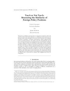
Fig. 4. A — If uniform crustal thickening occurs under the Issyk Kul’ basin (top part of the figure), this will initially cause the surface heat flow to decrease as the “stacking geotherm” (black curve in the lower left part of the figure) re-equilibrates. However, thickening the crust will increase radioactive heat production, and, eventually, the heat flow will increase. This evolution of the heat flow with time is shown by the black curve on the lower right part of the figure. B — The lithospheric folding model (central part of the figure) does not involve uniform crustal thickening. Subsequently, it does not change the geotherm, nor cause an increase in the equilibrium heat flow (gray curves in the lower part of the figure).
in the Tien Shan and comparable settings: the “uniform crustal thickening” and the “lithospheric folding” models (Fig. 4). “UNIFORM CRUSTAL THICKENING” MODEL The deformation of the mountain range is dominated by thrusting. Horizontal shortening is almost entirely accommodated by crustal thickening, which is thought to occur uniformly across the Tien Shan (e.g. [1]). In conditions of thermally steady state, we expect a uniformly thickened crust to result in an elevated heat flow through an increased contribution of radioactive decay. Since we do not observe an elevated heat flow, if we want to preserve our hypothesis of uniform crustal thickening, we must conclude that the Issyk Kul’ basin is not in a thermally steady state. According to the “stacking” model, the activity of thrust faults brings warm material from the deeper crust on top of cold material that was originally near the Earth’s surface. This results in a nonsteady state “sawtooth”-geotherm [33]. In a first stage, heat is transferred from the lower, hot part of the upper thrust sheet, to the underlying, colder material. Therefore, less heat-flows to the upper surface. After this initial lowering of the surface heat flow, the situation gradually returns to normal, and eventually reaches a steady state, which, 581
Russian Geology and Geophysics
Vol. 45, No. 5
thus, is associated with higher heat flow than before the crustal thickening (Fig. 4). This “stacking” model has been proposed to explain low heat flow values in the Andes [34]. It seems not to be by coincidence that the Andes are often considered to be the best geodynamic analog to the Tien Shan [27, 28]. “LITHOSPHERIC FOLDING” MODEL WITH RAMP BASINS The “stacking” model can explain the relatively low heat flow of the Issyk Kul’ basin as being a transient phenomenon. The two conditions for nonelevated heat flow in thermal steady state are 1) a nonthinned lithosphere, to prevent an increase of asthenospheric convective heat input, and 2) a nonthickened crust, which would yield extra radioactive heat. Both of these conditions are fulfilled by the model of lithospheric folding [24, 30]. Gravimetric measurements show a periodicity with wavelengths of 50 and 300–360 km [35]. This corresponds to the large-scale topographic features of Central Asia. Thus, lithospheric folding could explain the location of e.g. Lake Balkhash in Kazakhstan, but also Lake Issyk Kul’, which would then be part of the same “wavelet” as the Chu basin [35, 36]. Thus, Issyk Kul’ would be situated in the trough of a sinusoidal lithospheric fold. The culminations of the fold would then correspond to the Terskey and Kungey mountain ranges. If horizontal shortening causes the lithosphere to fold, no major lithospheric thinning is required. This fulfils the first condition for a steady state explanation of the nonelevated heat flow (Fig. 4). The second condition (no uniform crustal thickening) is also fulfilled, since the model predicts thrusting to occur from the ridges to the troughs, so that an increase in radioactive heat production is only confined to the mountain ranges. Another factor, which most likely comes into play, is hydrological drive. 40% of the lake’s water input is thought to be groundwater [20]. Hydrologic effect on heat flow is known to often have a large spatial variability. This is not observed for the measurement stations located in the central lake basin. The groundwater effect will however most likely be, at least partially, responsible for the wider range of heat-flow values observed on-shore. The standard error of the land data is 6.8 mW/m2, as compared with 2.3 mW/m2 for the new data. CONCLUSIONS New heat-flow data at the bottom of Lake Issyk Kul’ show an average flux of 48±2 mW/m2. Such a low heat flow is not what we would expect in an actively deforming tectonic environment. Furthermore, the Tien Shan is associated with crustal thickening and thus is expected to display an increased surface heat flow. Similar nonelevated heat flow in a tectonic setting of crustal shortening and thickening has been observed in the Andean Chaco foreland basin. Hence, low to normal heat flow may be a fundamental feature of intermontane basins. Two geodynamical models can account for the observed thermal conditions. If there is crustal thickening beneath Issyk Kul’, the low heat flow can only be explained in a transient mode, as described by a stacking model with “sawtooth geotherm”. In equilibrium conditions, low heat flow implies that there is no or only minor crustal thickening under the basin. This feature could be the result of lithospheric folding, as occurs throughout Central Asia. This phenomenon can lead to differential crustal thickening between the culminations of the folds (e.g. Terskey and Kungey Alatau ranges), with respect to the troughs (Issyk Kul’), which are thus not affected by an increased amount of radioactive heat. Acknowledgements. The research was funded by the Belgian Federal Office for Scientific, Technical and Cultural Affairs (OSTC), and J. Poort was supported by a grant offered by the Flemish Institute for support of Scientific and Technological research in the industry (IWT). Authors are also grateful to the participants of the geologo-geophysical expedition held in 1998 (R/V Meltur) when geothermal measurement were carried out. REFERENCES 1. Abdrachmatov, K.Y., S.A. Aldazhanov, B.H. Hager, M.W. Hamburger, T.A. Herring, K.B. Kalabaev, V.I. Makarov, P. Molnar, S.V. Panasyuk, M.T. Prilepin, R.E. Reilinger, I.S. Sadybakasov, B.J. Souter, Y.A. Trapeznikov, V.Y. Tsurkov, and A.V. Zubovich, Relatively recent construction of the Tien Shan inferred from GPS measurements of present-day crustal deformation rates, Nature, 384, 450–453, 1996. 2. Molnar, P., and P. Tapponnier, Cainozoic tectonics of Asia: effects of a continental collision, Science, 189, 4201, 419–426, 1975. 3. Imbo, Y., Study of the evolution of the Issyk Kul basin (Tien Shan, Kyrgyzstan) based on high-resolution reflection seismics. Licentiate thesis, Academic year 1997-1998, University of Ghent, 1998. 4. Shvartzman, Y.G., Thermal fields of the Kyrghyz Tien Shan, in Geological-Geophysical Study of Seismical Zones [in Russian], 100–119, Ilim, Frunze, 1984. 582
Russian Geology and Geophysics
Vol. 45, No. 5
5. Shvartsman, Y.G., Thermal regime of the Issyk Kul’ depression, in Geothermal investigations on the bottom of aquarium [in Russian], 35–41, Nauka, Moscow, 1988. 6. Duchkov, A.D., Yu.G. Shvartsman, and L.S. Sokolova, Deep heat flow in Tien Shan: advances and drawbacks, Geologiya i Geofizika (Russian Geology and Geophysics), 42, 10, 1516–1531(1436–1452), 2001. 7. Lyubimova, E.A., A.L. Aleksandrov, and A.D. Duchkov, Methods of heat-flow investigation through the ocean bottom [in Russian], 176 pp., Nauka, Moscow, 1973. 8. Matveev, V.G., and A.A. Rot, New devices for automation of marine geothermal investigations on shelf, in Geothermal investigations on the bottom of aquarium [in Russian], 98–107, Nauka, Moscow, 1988. 9. Cobbold, P.R., E. Sadybakasov, and J.C. Thomas, Cainozoic transpression and basin development, Kyrghyz Tien Shan, Central Asia, in F. Roure, N. Ellouz, V. S. Shein, I. Skvortsov (Eds.), Geodynamic Evolution of Sedimentary Basins, International Symposium 181–202, Moscow, 1994. 10. Buntebarth, G., Geothermics, an introduction, Springer Verlag, Berlin—Heidelberg, 1984. 11. Lachenbruch, A.H., Rapid estimation of the topographic disturbance to superficial thermal gradients, Rev. Geophys., 6, 365–400, 1968. 12. Rasmussen, K.A., R.D. Ricketts, T.C. Johnson, V.V. Romanovsky, and O.M. Grigina, An 11,000-year history of Central Asian paleoclimate change recorded in deep sediments of Lake Issyk Kul, Kyrgyzstan, GSA 1998 Annual Meeting, Boulder, CO, Abstracts with Programs, GSA, 30, 7, 309, 2000. 13. Von Herzen, R.P., and S. Uyeda, Heat-flow through the eastern Pacific ocean floor, J. Geophys. Res., 4219–4251, 1963. 14. Kvasov, D.D., and J.P. Seliverstov, Quelques problèmes de la paléogéographie du bassin Issik-Coul, Oeuvres du laboratoire des lacs de l’Academie des Sciences de l’URSS, Moscow—Leningrad, 10, 45–54, 1960. 15. Lyubimova, E.A., and V.A. Shelyagin, Heat flow through the bottom of Lake Baikal, Dokl. AN SSSR, 171, 25–28, 1966. 16. Duchkov, A.D., S.A. Kazantsev, V.A. Golubev, S.V. Lysak, and E.S. Khaikovskii, The heat flow within Lake Baikal, Geologiya i Geofizika (Soviet Geology and Geophysics), 17, 4, 112–121(92–99), 1976. 17. Golubev, V.A., Geothermics of Baikal [in Russian], 150 pp., Nauka, Novosibirsk, 1982. 18. Poort, J. Significance of the surface heat-flow in the Baikal rift; inferences from spatial heat-flow analysis and numerical modelling. Ph.D. thesis, Free University of Brussels, 2000. 19. De Batist, M., Y. Imbo, P. Vermeesch, J. Klerkx, S. Giralt, D. Delvaux, V. Lignier, C. Beck, I. Kalugin, and K.E. Abdrakhmatov, Bathymetry and sedimentary environments of Lake Issyk-Kul: a large, high-altitude, tectonic lake, in J. Klerkx & B. Imanackunov (eds.), Lake Issyk-Kul: its Natural Environment. NATO Science Series IV. Earth and Environmental Sciences. Vol. 13, 101–121, 2002. 20. W.B. Lyons, K.A. Welch, J.-C. Bonzongo, E.Y., Graham, G. Shabunin, H.E. Gaudette, and R.J. Poreda, A preliminary assessment of the geochemical dynamics of Issyk-Kul Lake, Kirghizstan, Limnol. Oceanogr., 46, 3, 213–218, 2001. 21. Lewis, T. (Ed.), Climatic change inferred from underground temperatures, Global and planetary change, 6, 2/4, 281 pp., 1992. 22. Duchkov, A.D., L.S. Sokolova, V.T. Balobaev, V.N. Devyatkin, V.I. Kononov, and S.V. Lysak, Geothermal field, climate and permafrost, in Global changes in environment and the climate. Selected scientific papers. Special issue [in Russian], 232–232, Scientific council of the Federal research program of Russia, State scientific and research center for warning geoecological and technogeneous disasters, Moscow Branch SSRC WGD Ministry of Education of Russia, Moscow, 1996. 23. Dewey, J.F., S. Cande, and W.C. Pitman, Tectonic evolution of the India/Eurasia collision zone, Eclogea Geologica Helveticae, 82, 3, 717–734, 1989. 24. Cobbold, P.R., and P.H. Davy, Indentation tectonics in nature and experiment. 2. Central Asia, Bull. Geol. Inst. Univ. Uppsala, N.S. 14, 143–162, 1988. 25. Tapponnier, P., G. Peltzer, A.Y. Le Dain, R. Armijo, and P. Cobbold, Propagating extrusion tectonics in Asia: new insights from simple experiments with plasticine, Geology, 10, 611–616, 1982. 26. Thomas, J.-C., H. Perroud, P.R. Cobbold, M.L. Bazhenov, V.S. Burtman, A. Chuvin, and E. Sadybakazov, A Paleomagnetic study of Tertiary Formations from the Kyrgyz Tien-Shan and Its Tectonic Implications, J. Geophys. Res., 98, 9571–9589, 1993. 27. Cobbold, P.R., P. Davy, D. Gapais, E.A. Rossello, E. Sadybakasov, J.C. Thomas, J.J. Tondji Biyo, and M. Urreiztieta, Sedimentary basins and crustal thickening, Sedimentary Geology, 86, 77–89, 1993. 28. Cobbold, P.R. Active tectonics of Central Asia and South America; similarities and differences, in GSA 1996 Annual Meeting, Boulder, CO, Abstracts with programs — GSA, 28, 7, 111–112, 1996. 29. Trofimov, A.K., V.A. Drushits, and A.B. Meskheteli, Issyk Kul’ Lake; principal features of geological 583
Russian Geology and Geophysics
Vol. 45, No. 5
structure and development of lake basins, in A.F. Treshnikov (Ed.), History of Sevan, Issyk Kul’, Balkhash, Zaisan and Aral lakes [in Russian], 57–67, Nauka, Leningrad, 1991. 30. Burov, E.V., M.G. Kogan, H. Lyon-Caen, and P. Molnar, Gravity anomalies, the deep structure, and dynamic processes beneath the Tien Shan, Earth Planet. Sci. Lett., 96, 367–383, 1990. 31. Vinnik, L.P. and Saipbekova, Structure of the lithosphere and the asthenosphere of the Tien Shan, Annales Geophysicae, 2, 6, 621–626, 1984. 32. Roecker, S.W., T.M. Sabitova, L.P. Vinnik, Y.A. Burmakov, M.I. Golvanov, R. Mamatkanova, and L. Munirova, Three-dimensional elastic wave velocity structure of the western and central Tien Shan, J. Geophys. Res., 98, 15779–15795, 1993. 33. Midgley, J.P., and D.J. Blundell, Deep seismic structure and thermo-mechanical modelling of continental collision zones, Tectonophysics, 273, 155–167, 1997. 34. Springer, M., and A. Forster, Heat-flow density across the Central Andean subduction zone, Tectonophysics, 291, 123–139, 1998. 35. Burov, E.B., L.I. Lobkovsky, S. Cloetingh, and A.M. Nikishin, Continental lithosphere folding in Central Asia (Part II): constraints from gravity and topography, Tectonophysics, 226, 74–87, 1993. 36. Nikishin, A.M., S. Cloetingh, L.I. Lobkovsky, E.B. Burov, and A.C. Lankreijer, Continental lithosphere folding in Central Asia (part I): constraints from geological observations, Tectonophysics, 226, 59–72, 1993. Editorial responsibility: S.V. Gol’din
Received 20 September 2002
584