Syntactic and Network Pattern Structures of City - Comparison of Grid and Meandering Street Patterns in Kyojima and Honjo Napong Nophaket*1 and Akira Fujii2 1
Lecturer in Architectural and Urban Design, Mahasarakham University, Thailand; Doctoral Graduate, IIS, The University of Tokyo, Japan 2 Professor, Department of Human and Social Systems, Institute of Industrial Science, The University of Tokyo, Japan
Abstract This paper analyzes the relationship between livability and structure of two towns in Sumida city, Tokyo. Being historically and spatially contrasted despite located nearby, Kyojima and Honjo are comparatively analyzed under two different methods. According to a well-established topological analysis of city by Hillier (1998), Space Syntax’s Axial Map is applied to evaluate ‘syntactic intelligibility’ and the degree of ‘natural movement’ at both towns. Based upon ‘Graph Geometry’ proposed by Nophaket (2004 a), the towns’ minimum-path structures are also detected. The network analysis applies Dijkstra algorithm to visualize the ‘Network Pattern’ of street structure via C-language computer simulation (Nophaket, 2004 b). Comparison between topologicalsyntactic structure and geometrical-network pattern testifies not only significant contrasts in street patterns of Kyojima and Honjo, but also the different logic between two analytical models. Whilst Axial Map specifically shows the quantitative correlation between ‘integration value’ and pedestrian or vehicle flow rate on each straight line, the new Path Map of Network Pattern detects an overall ‘qualitative pattern’, the organic grid of winding streets in particular. Importantly, it shows the vital linkage of city. This study can conclude that Space Syntax model based on depth analysis implies a macro structure of city. Network Pattern, by contrast, represents the metrical significance of street at a more detailed level. The research findings, therefore, challenge an accepted generalization of applying Space Syntax across different cultures, archetypes and scales of street patterns. Moreover, it includes the geometrical analysis into basic graph-network study of urban form. As we believe, it is this metrical importance of street pattern that has been lost, perhaps not fully justifiably, within traditional Space Syntax analysis of the city. Keywords: street pattern; space syntax analysis; network pattern analysis; town center; livability
1. Introduction This paper analyzes street structure and livability of two towns. It uses Space Syntax and Network Pattern methods to compare with historical data, land use, and movement flow from field observation. Despite meandering street pattern, normally defines as a less ‘intelligible’ city form than ‘deformed grid’ pattern (Hillier, 1999), Kyojima’s street is lively not only on particular shopping streets. This quality and higher numbers of pedestrian counted over streets define high livability of Kyojima in this study (Figure 3). Although located nearby, Kyojima and Honjo represent a pair of strongly contrasted street patterns and observable community life styles. The paper’s first part reviews their historical and morphological developments
*Contact Author: Napong Nophaket, Fujii-Magaribuchi Laboratory, 5th-section, Institute of Industrial Science, The University of Tokyo, Cw-701 4-6-1 Komaba Meguro Tel: 03-5452-6378 Fax: 03-5452-6375 Email:
[email protected],
[email protected] (From October 1st 2004) (Received May 14, 2004; accepted September 13, 2004)
after theoretical background. Then the second part applies Space Syntax and Network Pattern to study street patterns in Honjo and Kyojima. Proposed by Hillier (1993, 1996b) the theories of ‘natural movement’ and ‘movement economy’ are tested. The overall connectivity of street called ‘integration’ value is correlated to movement volume counted over the streets. Drawn over official street map provided by Sumida city (Sumida city, 2002) at scale 1:10,000 including private streets (corrected by ground observation), Axial Map analysis is used to retrieve ‘intelligibility’. To show how a city is tangible, intelligibility is the degree of good correlation between local (R3) and global integrations (Hillier & Hanson 1984). For each town, ‘Gate Observation’ method counts total footfalls and vehicles over a set of forty street segments within two weekdays. Flow over each gate is counted for three 7-minute periods (during 9-12; 12-15; 15-18) of a day. Then, we use average flow values to make correlation diagram with the integration values of those streets (Figure 3). To clarify the relation between street structure and use phenomena of city, Part II conducts area observation, historical review and a study of existing building uses.
Journal of Asian Architecture and Building Engineering/November 2004/356
349
It gives findings with an empirical support to Space Syntax theory. However, limitation of Axial Map to describe the street pattern of Kyojima, which being syntactically less intelligible but actually livelier, is left for another explanation. The third part discusses the difference between syntactic and network analyses and asks how could Kyojima become a ‘meaningful urban identity’ (Lim, 1990). It is a greatly livable and walkable neighborhood with Tachibana Ginza, a small shopping alley as its major local integrator (Kitahara, 2001). By reanalyzing Kyojima’s winding street pattern using shortest-path study proposed in Nophaket (2004 a), liveliness in Kyojima and its relations with the geometrical structure are shown. The paper concludes that the street pattern of Kyojima is lively because it is metrically, rather than syntactically, intelligible. Part I: Theoretical context and Case study 2. Towards a spatial theory of town center In the first half of 20th century, modernist planners hoped that new physical intervention into city would significantly improve urban living condition. In the later half, however, we soon recognized the modernist’s physical determinism. Without empirical understanding, certain modernist plans naively intervened and eliminated the life of traditional community (Jacobs, 1961). The recent ‘new urbanism’ returns to traditional city forms with nostalgia, but still lack any empirical prove that it would give a better result than modernist intervention. The city is complex but we not yet have any rigor representation of city with a truly reliable analysis. Therefore, urban research still unable to differentiate effects between various forms of urban complexity (Hillier, 1998). An underlying problem, we believe, lies in the old misconception that city is primarily an object for which new physical intervention can improve its ‘life’. As a research on spatial structure of city, this paper turns space into foreground to consider the capacity of street patterns for creating urban life. Significance of space to generate society, community life and its structure, is the major concern of Space Syntax theory (Hillier and Hanson, 1984). This is true also for other theoretical frameworks. For examples, in urban sociology, the concepts of human ecology (Hawley, 1971) and social morphology (Schnore, 1982), based on Emile Durkheim’s Division of Labor (1893), also consider space and its organizing role of human community as a structural property of our society. In architecture Foucault (1979) and Markus (1987) also see building as spatial model of power. As a social product, architecture accommodates power involved in space and society (Choi, 2003). Compared to physical determinism in urban design, these socio-spatial theories are generally more useful to investigate how street pattern of city can create lively community.
350 JAABE vol.3 no.2 Nov. 2004
3. Morphology and Life in Honjo and Kyojima Morphology research of city partly emerges from cultural landscape ( Kulturlandschaft ) and urban landscape ( Stadtlandschaft ). M.R.G. Conzen, is an important founder of urban morphology research in English speaking world (Larkham, 1998). In early period the focus was in historical development of urban form. However, recent urban geography has become more analytical and, hence, closer to our recent study on the street structure. For examples Moudon (1994) attempted at ‘rich data base on (urban) form and form making process’ and the Glossary of Urban Form (Jones and Larkham, 1991) highlighted the concept of type and archetype. Architectural analysis of building and city forms is closer to our study. J.P. Steadman (1983) studied ‘Architectural Morphology’, by analyzing building form with various geometrical concerns. It includes accessibility analysis by topological graph network. In parallel, Hillier and Hanson (1984) applies ‘justified graph’ (Figure 1) and concept of space configuration to explain the crucial relationship between spatial organization and social formation. With these bases, Part II of this paper analyzes geometrical and topological patterns of urban street. In the following, Kyojima and Honjo are reviewed under the light of the earlier typohistorical urban morphology theory. As shown in a reconstructed Edo map (Figure 2), Kyojima and Honjo could not be more contrast in their physical appearance. If we look back into their history, they are not only geographically but also socially different in their developments. It is only in the present time, under the influence of modernization and open capital economy, that their buildings and social living have become seemingly similar. In Edo era (A.D.16041868), Tokugawa shogunate’s Bakufu law had regulated their social functions, economic status and characteristics. Kyojima was designated as a farming village, where houses were surrounded by farmland and the whole morphology dominated by natural topography, especially the river and irrigation canals. Socially, village life was peaceful because only the samurais (warrior class) were allowed to arm. In contrast, Honjo was a commercial town under Bakufu law. In an obvious way, this fact is shown in the town’s overall morphology that strongly continued into present time. Honjo is a neat perpendicular grid, where efficiency in transportation of people and goods and connectivity among business were necessary for the town’s economic development. In short, we can see that the Bakufu law of Edo had influentially generated both morphology and community life of Kyojima and Honjo. They are different for their social functions as much as physical morphology. In the next part, this paper examines the physical structure of the towns with two methods, namely Space Syntax and Network Pattern principles. Observed vehicle and pedestrian movement and the degree of intelligibility
Napong Nophaket
are testified. Then, in the last part of this paper we discuss the analysis results, merit and limitation of syntactic method, and specific findings from the Network Pattern principle. Part II: Two Methods of Analysis 4. Space Syntax and Network Pattern The specific urban structure, the street pattern, of Kyojima and Honjo are analyzed in two parts. The first part is a traditional Space Syntax analysis. Axial analysis provides integration and intelligibility values which are testified with pedestrian and vehicle uses. Moreover, recent land and building uses at both town centers are reviewed. The second analysis uses new framework of Network Pattern principle. It is a different approach to study the metrical shortest-path of urban street pattern (Nophaket, 2004 a, b). Figure 1 shows that significance of a node, or street junction, bases on how near it is from every other node. Significance of an edge, or street segment, bases on how many shortest-paths between every pair of nodes pass on it. 4.1 Space Syntax Analysis In this analysis, we use configuration principle of Space Syntax to study the relation between livability and street pattern. It is tested with observation of pedestrian and vehicle movement on real space. Then, merit and limit of Space Syntax can be discussed. Space Syntax theory (Hillier and Hanson, 1984) provides the principle of ‘natural movement’. It states that, in an intelligible urban center, usually about three-forth of pedestrian movement correlates with the integration value of each street’s straight axial line. Integration value shows how the street would be deep or shallow from any other street within the same Axial Map. Natural movement assumes that the lower mean depth the line, the more integrated the street and the higher volume of pedestrian flow. When the integration-movement correlation is low, the theory describes such area as being unintelligible or affected by attractors like major transport station and shopping centers (Hillier, 1993). ‘The Common Language of Space’ (Hillier, 1998) sums up that natural movement and movement economy principles are working together to generate pedestrian uses of urban space which, in effect, bring the economy of land use that draw a lesser or greater degree of movement to the city. In short, space pattern or ‘configuration’ is a key element for the functioning of urban center. However, the space configuration in Figure 1 purely depicts a topological character of the pattern, regardless any geometrical distance among spaces. The findings of Space Syntax, movement and morphological analyses for Kyojima and Honjo include three important points. - First, the two towns express different history through their different space patterns. Kyojima was an inclusive farming village being socially closed and peaceful,
JAABE vol.3 no.2 Nov. 2004
whilst, Honjo was planned as ‘shitamachi’, a commercial town for Edo’s commoners (Fig.2 and 3). Land uses at both towns relate with the syntactic structure (Figure 4 and 6). Locally integrated streets are lined up with shops in both areas. Nonetheless, shops are concentrated highly along major streets in the irregular grid of Kyojima, while being diffused more evenly into most area of Honjo.
Fig.1. The contrast between two analyzes, Space Syntax (upper) and Network Pattern (lower). It is the difference between topological and geometrical relations among all spaces in the same system. See details in Nophaket 2004 a, b
- Second, ‘natural movement’ exists quite clearly in Honjo, but not in Kyojima. This refers to the fact that highly regular grid of Honjo is much more intelligible than winding pattern of Kyojima. The global and local integration correlations in Figure 3 give r2 0.802 and 0.646 for Honjo and Kyojima, respectively (Table 1). Consequently, vehicle movement rates along 30 observed streets in Honjo can be predicted precisely by integration r-3 values taken from Sumida’s Axial Map (Figure 2 and 3). Table 1 and Figure 3-1 show high correlation value of r2 0.846, the value for pedestrian flow is 0.599. The same values for Kyojima area are 0.542 and 0.368 and scatters in Figure 3-2 are bifurcated. For, Kyojima, these could hardly confirm ‘natural movement’ and ‘movement economy’ purely based on the topological graph analysis of Space Syntax. - Last, the significant contrast between two areas is that whereas space use in Honjo relates to street integration values, space use in Kyojma could be a function of its locality. Local shops and major shopping street in Kyojima become main attractors of the town. They are both highly intelligible and geometrically central (Fig.5, 6). They dominate pedestrian use of space strongly, compared with pure configuration values. This finding confirms that for pedestrian walking in an irregular street pattern, local attributes including land use and geometrical distance are more significant than purely abstract topological configuration proposed by Space Syntax.
Napong Nophaket
351
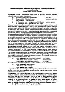
Fig.2. Above: Historical map (Edo) of Kyojima and Honjo with Space Syntax Axial Map of Sumida city and Intelligibility correlation between Integration RN (global) and R3 (local) of each town. Right: Network Pattern analysis -the Path Map- of the whole Sumida city. Clearly, within Sumida, Kyojima is metrically significant linkage-path to link each street junction with every other.
Fig.3-1. Honjo correlations between pedestrian and vehicle flow on the same streets (left); pedestrian flow and local integration (middle); and vehicle flow and local integration (right). This area is syntactically highly intelligible, and thus, has a high predictability of vehicle flow. (See also Table 1)
Fig.3-2. Kyojima correlations between pedestrian and vehicle flow on the same streets (left); pedestrian flow and local integration (middle); and vehicle flow and local integration (right). This area is syntactically less intelligible, and thus, has a lower predictability of both pedestrian and vehicle flow. Noted that the correlation between pedestrian and vehicle passing same streets is considerably poorer than that of Honjo, here it shows a T-shaped scatter. (See also Table 1)
352 JAABE vol.3 no.2 Nov. 2004
Napong Nophaket
Fig.4. Existing land use of Honjo (left) and Kyojima (right). Red signifies commercial use; yellow and green for residences; blue for industry; brown for public and instituition uses. Shops concentrates on major, integrated streets of Kyojima, while being more diffused in Honjo. Tachibana Ginza (circled) is locally significant. Kyojima has a very strong geometrical path structure.
Fig.5. Network Pattern analysis of two areas. It is constructed from geometrical shortest-path analysis, by applying Dijkstra algorithm. The Path Maps show street segments that have more shortest-paths (from each to every other junction) passing on as thicker, brighter. In Honjo it highlights the area where shops concentrate. For Kyojima it shows organic grid, the main linkage.
Fig.6. Space Syntax’s Axial Map expresses topological ‘depth’ structure of urban street structure. Red lines are the shallow cores depicting the main grid structures. However, Axial Map overlooks the local structures (shopping street shown in Fig.4). By contrast, the Path Maps in Figure 5 can highlight the local structure of winding street-pattern in particular.
JAABE vol.3 no.2 Nov. 2004
Napong Nophaket
353
Table 1. Space Syntax and Movement values at two towns
4.2 Network Pattern Analysis ‘Network Pattern’ analysis is a comparative tool to analyze street pattern to the Axial Map analysis of Space Syntax. Based on metrically shortest-path distance from each to every other street junction (Figure 1), the new model visualizes hierarchical importance among all street junctions and segments within the same system (Nophaket 2004 a, b). In previous study (2004 a), Path Map of Bangkok city is proved to pick up the city’s local grid, which is particularly significant at walking scale. The Path Map analysis of Kyojima in this paper shows a conforming result by highlighting locally significant shopping streets as main generator of town’s livability (Figure 5). It is obvious therefore that, despite winding street-pattern that syntactically more complex, Kyojima locates on metrically important paths. The town becomes the major linkage in Sumida city and being very lively for this reason. This fact is revealed in Network Pattern’s Path Map of Sumida in Figure 2. From syntax study, we can see that regular grid of Honjo is intelligible and, therefore, the syntactic depth in itself strongly draws vehicle movement. In contrast, Kyojima’s street pattern is meandering. It is less intelligible and vehicle movement is less predictable. Clearly, in both cases pedestrian flow conforms to syntax structure less than vehicle flow. If we look at the correlations between vehicle and pedestrian flows (Table 1), it is clear that pedestrian and car are much more coincided in a regular grid pattern of Honjo than in a winding street pattern of Kyojima. Walking in Kyojima streets then, how pedestrian accommodate themselves with any structure of the town? Observing the area, Kyojima is far from being unstructured. Shops lie up along certain streets and draw movement persistently throughout a day. People walk with familiarity, through curving streets, and get to certain pocket parks with ease. Therefore, for pedestrian it may not be fully justified to say that Kyojima is less tangible, nor less livable, than Honjo. Although syntax values of Honjo is higher, the area obviously has no lively shopping streets, use of pocket park or chatting on streets. What, then, draw pedestrian live to Kyojima? Being syntactically less intelligible does not mean that the area is less structured. If we analyze the geometrical shortestpath structure of Kyojima, using the graph provided in Figure 1 (lower), its local grid structure can be encapsulated (Figure 2 Right). Described more thoroughly in previous paper (Nophaket, 2004 a), this
354 JAABE vol.3 no.2 Nov. 2004
Path Map draws thicker line for the segment being passed more often, given equally distributed traverse that pass only through ‘shortest-path’ once form each to every other junction of the map. The geometrical structure of Kyojima picks up both major shopping streets as well as other wider ‘through’ alleys that link residences to shops. In overall, despite not being syntactically structured nor based on a perpendicular grid as Honjo, Kyojima owes another type of shortest-path grid structure. Its street pattern is meandering but being geometrically structured into certain form, the one that can arrange both trip efficiency and street livability into the center of Kyojima community (Figure 2 and 5). Path Map clearly shows significantly linking paths, the metrical structure, in Kyojima that draw livability to the area. Part III: Discussion and Conclusion 5. Between Syntactic Configuration and Network Pattern Space Syntax theory is generally useful for street pattern analysis of town center, particularly for a regular street pattern, or a deformed grid as Hillier calls it. For regular pattern of Honjo, car movement can be well predicted by integration ‘radius 3’ (the mean depth of each axial street taking into account adjacent and nextstepped adjacent streets from a root). However, it is not difficult to see that regular deformed grid city and predictability of car movement in a dense, intelligible urban form are based primarily on European urban centers, like London and others. In contrast, street pattern of towns in Tokyo and those in other regions may not necessarily be archetypically similar to the Europeans. Studying Kyojima as an archetypically contrast morphology, the recent research both extends and, at the same time, challenges Space Syntax analysis. Based on graph network, Hillier insists that the geometry of Axial Map is already included in topological adjacency analysis (Hillier, 1999). He also argues that there could be a ‘generic’ level of spatial configuration of building and urban form across socio-economic and cultural contrasts. This generic level lies in topological structure of space in which the geometrical character i.e. the notion of nearness and farness in space is already included (Hillier, 1999). Never the less, there are many approaches trying to extend Space Syntax theory to cover non-traditional deform grid pattern of built form; for example in multilevel, less intelligible South Bank area of London (Chang and Penn 1998). Dalton (2003) also shows a choice of ‘angular depth’, which tries to include street direction into traditionally non-directional Axial Map. In comparison, our analysis of the Network Pattern of urban street applies the shortest-path centrality and linkage capacity as new configuration (Nophaket, 2004 a, b). In which condition that, as Hillier proposed, the topological adjacency among spaces or the notion he calls configuration could ‘already’ assume or even include geometrical property of space pattern?
Napong Nophaket
Trying to answer this question will both further clarify his notion of ‘configuration’ in relation with social formation in space, and will also point to the differences between car and pedestrian uses of space. In turn, this can differentiate two contrast space patterns, namely regular or deform grid (like Honjo) and irregular or less syntactically intelligible pattern (like Kyojima), and also describe why the notion of syntactic intelligibility seems to work better for a typical perpendicular grid. Configuration is proposed to evaluate the comparative relationship between two spaces based upon the relationship of each to the third. A clear comparison is the two pictures of two connected square cells A and B; in the first picture both open to outside space C, whilst in the second picture only A opens to C and the connected side of cell B opens to A (Hiller, 1996a). The first picture shows a symmetric relationship between A and B, since both of them are equally open to C in one step. By contrast the second means asymmetric and also nondistributed system according to C, since there is only one path form C to B by passing through A, without loop. This kind of configuration, therefore, is about ‘node adjacency’ in graph theory and has nothing to do with geometrical distance among nodes. Nor would it concern different weights of the edges, such as distance. This paper notes that there are at least two conditions in which topological configuration, that regardless geometric dimension, can suitably describe social formation in building and city. First, in an interior space particularly an open one like a Mongol tent as shown in various analyses of Space Syntax. The geometric distance seems to become less meaningful since everything can be seen all at once. Here topology of things; for examples, left and right-handedness, front or rare side of the tent, and central or periphery, according to host’s place and, particularly, to visitor’s entry direction to the tent, becomes obviously more important than distance to express social mean and formation within space. Second, to analyze city, Hillier strongly insists that it is the configuration among straight-street axial lines that form the global form of city. This global form needs to include the large system of all streets and its adjacency depth pattern. The larger and the more global the system, the more important the notion of topological adjacency becomes. In contrast, the less important the geometrical distance becomes. For the global form of city, individual distance can be a detail factor. Space Syntax analysis draws Axial Map of the whole Greater London to analyze small housing area (Hillier, 1998). For very large system, adjacency step(s), or ‘depth’ of all other lines from a root street, can reasonably replace metrical distance in one sense. Therefore, Axial Map is very suitable for automobile movement . Drivers would prefer straight ‘through’ streets, with fewer turns (integrated axial) though with longer metric distance, more than a shorter route but with many zigzag turns. Shortly, for the exterior space of city, Axial Map is more suitable to study ‘through-
JAABE vol.3 no.2 Nov. 2004
street’ (all-to-all) movement as in Honjo, than for pedestrian’s ‘to-street’ (point-to-point) movement as in Kyojima’s patchy street pattern. Therefore, Syntax is suitable for the global pattern of through movement. The Edo’s commercial town of Honjo was in intentionally planned as a regular grid certainly for this global efficiency. For these reasons, we can see in Table 1 that the city is syntactically more intelligible than Kyojima. Vehicle movement can be predicted more precisely. By contrast, Kyojima has very different logic. Due to a winding street pattern, Space Syntax cannot explain its significance. However, as shown in the Network Pattern analysis Kyojima is metrically important. In short, its tangible structure and livability base on the metric logic. Network Pattern and Life of Town Center Why Kyojima streets are lively and can give pedestrian a good structure to walk around and understand the area? To give reasonable answer, one may prefer further detail studies in morphological development, everyday space use, land use and location of attraction buildings, etc. But they are very specific detail studies. Without structural study of overall space pattern and its relation with real use, studies possibly mislead to an endless discussion. To avoid describing Kyojima’s street pattern by purely based it on local phenomena (or semantic study of individual place), and to extend structural study of winding street pattern that Space Syntax alone cannot fully account for, this paper has presented the Path Maps of the Network Pattern analysis. Despite a less comprehensible plan (syntactically less intelligible), Kyojima street pattern has metrically wellorganized path. Figure 5 shows that they form a legible grid core for the pedestrian walking within the area. Moreover, the ‘organic grid’ covers wide streets lied up with shops, and links them inward to residences inside the grid, as well as outward to peripheral area (Fig. 2). The grid also detects the main local shopping street Tachibana Ginza (Fig. 4, circled). Streets between it and major shopping streets (between circle and oval) are also highlighted. Certainly, although being less syntactically integrated than straight streets of Honjo both in the Axial Map of Sumida (Fig. 2) and those of each town (Fig. 6), they are local structure of Kyojima. Therefore, livability of Kyojima comes with this metrical structure of the city. 6. Conclusion By comparing the space structure of two towns under two analytical methods, Space Syntax and Network Pattern, this paper finds that the winding street pattern in Kyojima has formed organic-grid structure by highly concerning geometrical distance. By contrast, a regular grid pattern of Honjo is shown to be a case that can further confirm the structure of normal city, the one that being dominated by vehicle (through) movement and that syntactic depth (integration and intelligibility values) can account for. By contrast, liveliness of Kyojima seems to
Napong Nophaket
355
rely upon the geometrical grid. Although less legible in plan and uncomfortable for car, the grid is comprehensible to pedestrian who walk within and into the area. The organic grid is efficient and also conforms to land use. To sum up, being urbanized since Edo era, perpendicular grid plan of Honjo holds ‘natural movement’ proposed in Space Syntax’s topological theory. On the other hand Kyojima, as a farming village that naturally becoming a town but still structured on a patchy street pattern, is less topologically intelligible. However, the liveliness of this organic town is due to its geometrically comprehensible pattern. Moreover, local attractors such as daily shopping streets evidently draw pedestrian flow well over the streets’ integration values. The shops concentrate particularly on the geometrical path structure of the town, as shown in land use and Path Maps (Fig. 2, 4 and 5). Consequently, it is possible to see qualitative relation between space use and geometric structure of Kyojima (Fig 2 and 3). This is despite a bifurcation in the quantitative correlation between pedestrian flow and syntactic integration value. Therefore, the Network Pattern model of Kyojima, the Path Map, can visualize linkage structure of the town’s winding street pattern. This structure, in turn, importantly generates livability of the organic town. Acknowledgement The research is funded by the Thai Government’s doctoral scholarship for the first author. The Network Pattern program is designed by the two authors and written by the second author in supervision for the first authorís doctoral thesis. References 1) Ching, D. and Penn, A. (1998) Integrated multilevel circulation in dense urban areas. Environment and Planning B, 25, 507-538.
356 JAABE vol.3 no.2 Nov. 2004
2) Choi, Y. (2003) The spatial structure of power. Environment and Planning B, 30, 589-603. 3) Dalton, N. (2003) Storing directionality in axial lines using complex node depths. Proceedings of The 4th Space Syntax Symposium, 63. 4) Durkheim, E. (1893) De la division du travail social. Alcan Press. Simpson, G. (1933) Translated as, The Division of Labor in Society. Macmillan Press. 5) Foucault, M. (1979) Discipline and Punish: The Birth of the Prison. Vintage. 6) Hawley, A. (1971) Human Ecology, Space, Time and Urbanization. Urban Society. Ronald Press. 7) Hillier, B and Hanson, J. (1984) Social Logic of Space. Cambridge University Press. 8) Hillier, B. et al. (1993) Natural movement: or, configuration and attraction in urban pedestrian movement. Environment and Planning B, 20, 29-66. 9) Hillier, B. (1996a) Space is the Machine. CUP. 10) Hillier, B. (1996b) Cities as movement economies. Urban Design International, 1, 49-60. 11) Hillier, B. (1999) The hidden geometry of deformed grids: or, why Space Syntax woks, when it looks as though it shouldnít. Environment and Planning B, 26, 169-191. 12) Hillier, B. (1998) The Common Language of Space. Space Syntax Laboratory. www.spacesymtax.org. 13) Jacobs, J. (1961) The death and life of great American cities. Randomhouse. 14) Jones, N. and Larkham, P. (1991) A Glossary on Urban Form. Historical Geography Research no.26. Geo Books. 15) Kitahara, T. (2001) Conserving the walkable environment in the neighborhood. International Walking Conference Australia. 16) Larkham, J. (1998) Urban Morphology and Typology in the U.K. Typological Process and Design Theory. Aga Khan Program. 17) Lim, W. (1990) Search for meaningful identity. Cities for People. Select Books Pte. 18) Makus, A. (1987) Buildings as classifying devices. Environment and Planning B, 14, 467-484. 19) Moudon, V. (1994) Getting to know the built landscape: Typomorphology. Type and the Ordering of Space. VNR. 20) Nophaket, N. (2004 a) The Graph Geometry for Architectural Planning. JAABE, 3 (1), 157-164. 21) Nophaket, N. (2004 b) Analysis on Street Pattern using Network Theory: Network Pattern Model. Unpublished doctoral thesis. 22) Schnore, L. (1982) Social Morphology and Human Ecology. Theodorson, G. ed. Urban Patterns. Penn State Press. 23) Steadman, P. (1983) Architectural Morphology. Pion. 24) Sumida City (2002) Sumida City Street Map 1:10,000. Sumida.
Napong Nophaket