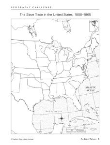
Geography Skills Analyze the maps in “Setting the Stage”. Then answer the following questions and fill out the map as directed. 1. Outline the border of the slave states on your map. Which rivers were along the border between slave states and free states? Locate and label them.
2. Locate and label each of the slave states. Which of them had the largest slave population in 1860?
Which slave state had the least number of slaves? How can you tell?
3. Find the major slave trade centers on the map in your book. What role did these cities have in the slave trade?
Which cities outside the slave states were involved in the slave trade?
4. Which new slave states entered the Union between 1812 and 1845? Draw a star for each one.
5. Which three of the new slave states were most important to the growth and expansion of slavery? How can you tell?
6. From which three states were slaves sold in the slave market at Montgomery, Alabama, likely to have come? Write the state names here, and circle them on your map.
7. In which two states were slaves sold in Kentucky likely to end up? Write the state names here, and shade them on your map.
8. How were slaves transported to be sold in the slave markets at Pensacola and New Orleans? From which states were they transported? Underline those state names.
9. Which slave market was probably the main source from which slaveholders in Arkansas purchased slaves? Label this slave trade center.
Critical Thinking Answer the following questions in complete sentences. 10. Why do you think most of the slaves sold to slaveholders in Texas arrived by sea?
11. Why do you think certain parts of the South had large numbers of slaves, while other parts did not?
12. From the routes shown on the slave trade map, why would it have been easy for slave traders to illegally bring slaves into the United States from islands in the Caribbean?
... shown on the slave trade map, why would it have been easy for slave traders to illegally bring slaves into the United States from islands in the Caribbean?
Which cities outside the slave states were involved in the slave trade? 4. Which new slave states entered the Union between 1812 and 1845? Draw a star for.
trade (inset map). Most slaves did not tell about their passageâmany died, and those who survived faced lives of bondage in the Americas. But some. Europeans .... AMERICA. AFRICA. EUROPE. Atlantic. Ocean. Pacific Ocean. New York. Charleston. Bahia.
United Nations Commission on International Trade Law. USTR ..... market, public services, medicines, food sovereignty and the agricultural sector. ...... also covered under a clause which authorizes the federal government to reimburse the.
Defendant to comply with its disclosure obligations under the Local Patent Rules ..... fact are relied upon [in a memorandum of law], supporting affidavits must be.
Nov 8, 2007 - (trial set to begin on February 4, 2008) and Lucent Techs., Inc. v. ..... 4 During the November 9 telephone conference, GSK also informed the ...
Oct 20, 2009 - National Guard. (Id. ¶¶ 8, 11.) In addition, Mr. Kerchner states that his is particularly harmed by the alleged uncertainty surrounding President Obama's birthplace because âwhile currently ... Minnesota State Bd. for Community Col
Petitioners, v. LG ELECTRONICS, INC. Respondent. On Writ of Certiorari to the United States. Court of Appeals for the Federal Circuit. BRIEF OF DELL INC., HEWLETT-PACKARD,. CO., CISCO SYSTEMS, INC., AND EBAY INC. AS AMICI CURIAE. IN SUPPORT OF PETITI
Sep 6, 2006 - See application ?le for complete search history. LLP. (56) .... Khosrowpour sentation downloaded from , (product. 5,999,952 A. 12/1999 Jenkins et al. to be released Mar. 1, 1997) 20 pages, unknown date. ... Windows/Article/ArticleID/ 30
Nov 13, 2006 - include the business environment of the recommendation ... Dynamic Consumer Pro?ling and Tiered Pricing Using Software. Agents, Prithviraj ...
There was a problem previewing this document. Retrying... Download. Connect more apps... Try one of the apps below to open or edit this item. pdf-1864\music-cultures-in-the-united-states-an-introduction-2005-01-02-by-unknown.pdf. pdf-1864\music-cultu