2010 Census Tracts within Bronx Community District 5 123 CD Community 2010 Census Tract District Boundary
Borough Boundary
°
Park
Miles 0.35
0
Note: Census tracts and community district boundaries are not coterminous. Some census tracts span multiple community districts or park areas. For census tract data visit Census FactFinder at maps.nyc.gov/census.
Source: MapPLUTO™ V.16.2, BYTES of the Big Apple. Created: August 2017.
2010 Census Tracts within Bronx Community District 5 - GitHub
Note: Census tracts and community district boundaries are not coterminous. Some census tracts span multiple community districts or park areas. For census tract data visit Census FactFinder at maps.nyc.gov/census. Community. District Boundary. 2010 Census Tract. Park. 123. CD. Borough. Boundary.
Note: Census tracts and community district boundaries are not coterminous. Some census tracts span multiple community districts or park areas. For census tract data visit Census FactFinder at maps.nyc.gov/census. Community. District Boundary. 2010 Ce
Note: Census tracts and community district boundaries are not coterminous. Some census tracts span multiple community districts or park areas. For census tract data visit Census FactFinder at maps.nyc.gov/census. Community. District Boundary. 2010 Ce
Note: Census tracts and community district boundaries are not coterminous. Some census tracts span multiple community districts or park areas. For census tract data visit Census FactFinder at maps.nyc.gov/census. Community. District Boundary. 2010 Ce
Note: Census tracts and community district boundaries are not coterminous. Some census tracts span multiple community districts or park areas. For census tract data visit Census FactFinder at maps.nyc.gov/census. Community. District Boundary. 2010 Ce
Note: Census tracts and community district boundaries are not coterminous. Some census tracts span multiple community districts or park areas. For census tract data visit Census FactFinder at maps.nyc.gov/census. Community. District Boundary. 2010 Ce
Note: Census tracts and community district boundaries are not coterminous. Some census tracts span multiple community districts or park areas. For census tract data visit Census FactFinder at maps.nyc.gov/census. Community. District Boundary. 2010 Ce
Note: Census tracts and community district boundaries are not coterminous. Some census tracts span multiple community districts or park areas. For census tract data visit Census FactFinder at maps.nyc.gov/census. Community. District Boundary. 2010 Ce
Created: August 2017. 0. 0.4. Miles. °. Community District. Boundary. 2010 Census Tract. Park. Note: Census tracts and community district boundaries are not coterminous. Some census tracts span multiple community districts or park areas. For census
Note: Census tracts and community district boundaries are not coterminous. Some census tracts span multiple community districts or park areas. For census tract data visit Census FactFinder at maps.nyc.gov/census. Community. District Boundary. 2010 Ce
This metric from the Mayor's Office for Economic Opportunity accounts for NYC's high cost of housing, as well as other costs of living and anti-poverty benefits. Land Use Category. % Lot. Area. # Lots. Click here for a more detailed land use map of B
Crotona. Park. Tremont. Park. Sherman. Creek. Devoe. Park. St. James. Park. C lare m o n t. P ark. Bridge Park. Highbridge. Park. Harlem River Park. PRO. SPECT AV. OA. K. TR. EE. PL. EA. ST. 183 ST. HIG. H. BR. ID. GE. EA. ST. 181. ST. GRAND CONCOURS
for Public Use Microdata Areas (PUMAs). PUMAs are geographic approximations of community districts. BX 2 shares PUMA 3710 with BX 1, and the ACS population estimate cannot be reliably disaggregated. 5NYC Dept of City Planning Facilites Database (2017
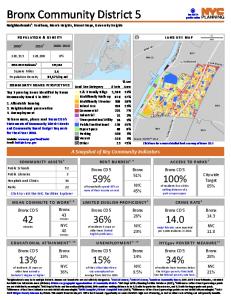
Square Miles. Population Density. 2.2. 41,590/sq mi. [. 0.5. Miles. 1Neighborhoods may be in multiple districts. Names and boundaries are not officially designated. 22000 US Census; 32010 US Census; 4American Community Survey 2011-2015 5-Year Estimat
2015 NYCgov Poverty Measure by PUMA. This metric from the Mayor's Office for Economic Opportunity accounts for NYC's high cost of housing, as well as other costs of living and anti-poverty benefits. Land Use Category. % Lot. Area. # Lots. Click here
Street flooding. To learn more, please read Bronx CD 10's · Statements of Community District Needs · and Community Board Budget Requests · for Fiscal Year 2018. A Snapshot of Key Community Indicators. Website: www.nyc.gov/bronxcb10. Email: [email protected]
This metric from the Mayor's Office for Economic Opportunity accounts for NYC's high cost of housing, as well as other costs of living and anti-poverty benefits. Land Use Category. % Lot. Area. # Lots. Click here for a more detailed land use map of B
for Public Use Microdata Areas (PUMAs). PUMAs are geographic approximations of community districts. BX 3 shares PUMA 3705 with BX 6, and the ACS population estimate cannot be reliably disaggregated. 5NYC Dept of City Planning Facilites Database (2017