2010 Census Tracts within Manhattan Community District 12 123 CD Community 2010 Census Tract District Boundary
Borough Boundary
Miles 0.5
0
Note: Census tracts and community district boundaries are not coterminous. Some census tracts span multiple community districts or park areas. For census tract data visit Census FactFinder at maps.nyc.gov/census.
Source: MapPLUTO™ V.16.2, BYTES of the Big Apple. Created: August 2017.
2010 Census Tracts within Manhattan Community District 12 - GitHub
Note: Census tracts and community district boundaries are not coterminous. Some census tracts span multiple community districts or park areas. For census tract data visit Census FactFinder at maps.nyc.gov/census. Community. District Boundary. 2010 Census Tract. Park. 123. CD. Borough. Boundary.
Created: August 2017. 0. 0.4. Miles. °. Community District. Boundary. 2010 Census Tract. Park. Note: Census tracts and community district boundaries are not coterminous. Some census tracts span multiple community districts or park areas. For census
Note: Census tracts and community district boundaries are not coterminous. Some census tracts span multiple community districts or park areas. For census tract data visit Census FactFinder at maps.nyc.gov/census. Community. District Boundary. 2010 Ce
Note: Census tracts and community district boundaries are not coterminous. Some census tracts span multiple community districts or park areas. For census tract data visit Census FactFinder at maps.nyc.gov/census. Community. District Boundary. 2010 Ce
Note: Census tracts and community district boundaries are not coterminous. Some census tracts span multiple community districts or park areas. For census tract data visit Census FactFinder at maps.nyc.gov/census. Community. District Boundary. 2010 Ce
Note: Census tracts and community district boundaries are not coterminous. Some census tracts span multiple community districts or park areas. For census tract data visit Census FactFinder at maps.nyc.gov/census. Community. District Boundary. 2010 Ce
Note: Census tracts and community district boundaries are not coterminous. Some census tracts span multiple community districts or park areas. For census tract data visit Census FactFinder at maps.nyc.gov/census. Community. District Boundary. 2010 Ce
Note: Census tracts and community district boundaries are not coterminous. Some census tracts span multiple community districts or park areas. For census tract data visit Census FactFinder at maps.nyc.gov/census. Community. District Boundary. 2010 Ce
Note: Census tracts and community district boundaries are not coterminous. Some census tracts span multiple community districts or park areas. For census tract data visit Census FactFinder at maps.nyc.gov/census. Community. District Boundary. 2010 Ce
Note: Census tracts and community district boundaries are not coterminous. Some census tracts span multiple community districts or park areas. For census tract data visit Census FactFinder at maps.nyc.gov/census. Community. District Boundary. 2010 Ce
23%. Manhattan CD 12. LIMITED ENGLISH PROFICIENCY4 of residents 5 years or older have limited · English proficiency. Manhattan. 14%. 20%. NYC. 21%. Manhattan CD 12 of residents have incomes below the NYCgov poverty threshold. See the federal poverty
16%. 6%. NYC. 23%. Manhattan CD 6. LIMITED ENGLISH PROFICIENCY4 of residents 5 years or older have limited · English proficiency. Manhattan. 14%. 11%. NYC. 21%. Manhattan CD 6 of residents have incomes below the NYCgov poverty threshold. See the fede
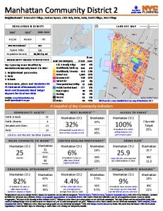
E 14 St. EastRiver. MN 6. MN 2. MN 1. Manhattan Community District 3. Neighborhoods1: Chinatown, East Village, Lower East Side, NoHo, Two Bridges. LAND USE MAP. 164,407. 163,277. -1% ... ACCESS TO PARKS7 of residents live within.
Park. MN 4. MN 6. MN 2. MN 8. Manhattan Community District 5. Neighborhoods1: Flatiron, Gramercy Park, Herald Square, Midtown, Midtown South, Murray Hill, Times Square, Union Square. Top 3 pressing issues identified by. Manhattan Community Board 5 in
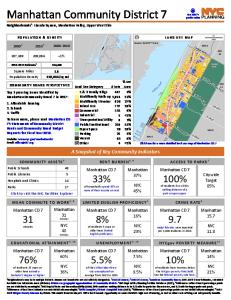
Page 1 ... E 79 St. MN. 11. Hudson. R iver. Central. Park. MN 9. MN. 10. MN 8. Manhattan Community District 7. Neighborhoods1: Lincoln Square, Manhattan Valley, Upper West Side. Top 3 pressing issues identified by. Manhattan Community Board 7 in 2017
for Public Use Microdata Areas (PUMAs). PUMAs are geographic approximations of community districts. MN 1 shares PUMA 3810 with MN 2, and the ACS population estimate cannot be reliably disaggregated. 5NYC Dept of City Planning Facilites Database (2017
E 125 St. 5 A v. Broad w ay. E 120 St. H u d so n. R ive r. MN 12. MN 10. MN 7. MN 11. Manhattan Community District 9. Neighborhoods1: Hamilton Heights, Manhattanville, Morningside Heights, West Harlem. Top 3 pressing issues identified by. Manhattan
for Public Use Microdata Areas (PUMAs). PUMAs are geographic approximations of community districts. MN 2 shares PUMA 3810 with MN 1, and the ACS population estimate cannot be reliably disaggregated. 5NYC Dept of City Planning Facilites Database (2017