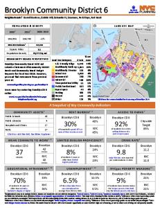
For Immediate Release January 29, 2015
BRIC AND BROOKLYN HISTORICAL SOCIETY PRESENT MAPPING BROOKLYN, AN EXHIBITION JUXTAPOSING HISTORIC MAPS WITH MAPPING-THEMED WORKS BY CONTEMPORARY ARTISTS On view at BRIC House (647 Fulton Street, Downtown Brooklyn): February 26 – May 3 Opening Reception: Wednesday, February 25, 7 - 9pm
On view at Brooklyn Historical Society (128 Pierrepont Street, Brooklyn Heights): February 26 – September 6 BRIC and Brooklyn Historical Society (BHS) are pleased to co-present Mapping Brooklyn, a new exhibition featuring contemporary art works that use mapping and cartography as themes alongside actual historic maps. Curated by Elizabeth Ferrer, Vice President of Contemporary Art at BRIC, and spanning the galleries at BRIC House (647 Fulton Street) and Brooklyn Historical Society (128 Pierrepont Street), Mapping Brooklyn explores the myriad ways that maps can represent practical matters such as wayfinding, property ownership, population shifts and war strategy, while also navigating the metaphorical, the psychological and the personal. At both venues, historic maps and contemporary works will be in dialogue, suggesting common themes—the desire to explore, chart, and analyze territory—and highlighting the innovative ways that contemporary artists use mapping, cartography and exploration, to reveal data, ideas and emotions. The historic maps will be drawn from BHS’s collection, one of the richest collections of maps of Brooklyn in the world. Included are fire insurance maps, transportation maps, demographic maps and nautical charts, among others. A colorful pictorial road map to the 1939 New York World’s Fair, a commercial edition of a Red Scare-era map depicting enclaves of suspected radical activity, and a detailed map of one of Brooklyn’s earliest botanic gardens, showing plots of exotic plants and fruits, are among the dozen or so maps and atlases on display. “We are thrilled to be partnering with BRIC on this fascinating study of how maps can influence art and self expression,” said Deborah Schwartz, President of Brooklyn Historical Society. “This exhibition not only allows us to share the wide range of historic maps in our collection, it also places these technical documents in a contemporary context to reveal their influence over universal ideas like the need to belong, the desire for representation, and the constantly changing nature of the borough and the world around us.” Artworks will range widely in scale and medium, including painting, photography, drawing, sculpture, installations, interactive projects, and appropriated and manipulated historic and contemporary documents. Many of the artists have conducted research into the BHS map collection and have selected the historic maps that will be shown alongside their work. Participating artists include Aaron Beebe, Daniel Bejar, Francisca Benitez, Gail Biederman, Justin Blinder, Christine Gedeon, Katarina Jerinic, Joyce Kozloff, Laura Kurgan, Peter Lapsley, Jennifer Maravillas, Simonetta Moro, Bundith Phunsombartlet, Jan Rothuizen, Patricia Smith, Nick Vaughan & Jake Margolin, and Sarah Williams.
Works include a monumentally scaled map of Brooklyn by Jennifer Maravillas, made from paper litter collected on epic walks through every block in the borough; a nine-foot diameter walk-in globe painted with aerial maps of sites involved in U.S. military warfare, by Joyce Kozloff; a special project by Amsterdam-based artist Jan Rothuizen, who will retrace the steps a 17th-century Dutch explorer laid years ago and document his modern-day journey with a series of drawings of people and places in contemporary Brooklyn; and digitized maps that study such phenomena as human emotions as tracked and mapped by Foursquare and created by data visualization designer and geographer Sarah Williams. Elizabeth Ferrer, Vice President of Contemporary Art at BRIC, says, “Modern and contemporary artists have long turned to maps for inspiration. In practical terms, maps provide information on navigating from point a to point b, but in metaphorical terms, they become the springboard for thinking about history, personal exploration, social and political issues, and our place in the world. I’m excited about the highly innovative ways that the artists in this exhibition use ideas drawn from mapping to create varied works exploring a range of issues and creative ideas.” The exhibition will be accompanied by public programs and a brochure with essays by Elizabeth Ferrer, Vice President of Contemporary Art at BRIC and Deborah Schwartz, President of Brooklyn Historical Society. BRIC Arts | Media House is located at 647 Fulton Street (at Rockwell Place) in Downtown Brooklyn. Gallery hours are Tuesdays & Thursdays 10am-8pm; and, on all other days, 10am – 6pm. The gallery is closed Monday. Admission is free. Brooklyn Historical Society is located at 128 Pierrepont Street (at Clinton Street) in Brooklyn Heights. Museum hours are Wednesday to Sunday, 12 – 5pm. About Brooklyn Historical Society Founded in 1863, Brooklyn Historical Society is a nationally recognized urban history center dedicated to preserving and encouraging the study of Brooklyn's extraordinary 400-year history. Located in Brooklyn Heights and housed in a magnificent landmark building designed by George Post and opened in 1881, today's BHS is a cultural hub for civic dialogue, thoughtful engagement and community outreach. For more information, visit brooklynhistory.org. About BRIC Since its founding as a not-for-profit organization in 1979, BRIC has been the driving force behind a number of Brooklyn’s most widely renowned and beloved arts and media programs. In the borough that is now this country’s foremost creative hotbed, BRIC is unparalleled in its combination of artistic excellence, programmatic breadth and genuine accessibility. BRIC presents live music and performing arts (the Celebrate Brooklyn! Performing Arts Festival and BRIClab), contemporary art exhibitions and programs, and community media programs (Brooklyn Free Speech Television and Brooklyn Independent Media) that reflect Brooklyn’s creativity and diversity. In 2013, BRIC inaugurated a new era of service to the borough when it opened BRIC House, a 40,000 square-foot arts and media facility located in the cultural hub of Downtown Brooklyn, featuring a flexible state-of-the-art performance space, a major contemporary art gallery, artist workspace, and multiple television and media production studios. In 2013, BRIC inaugurated a new era of service to the borough when it opens BRIC House, a 40,000 square-foot arts and media facility located in the cultural hub of Downtown Brooklyn. BRIC House includes a flexible state-of-the-art performance space, a major contemporary art gallery, artist workspace, and multiple television and media production studios. Designed by Brooklyn-based architect Thomas Leeser, BRIC House aims to be a true home for artists and audiences—a place where emerging and established artists create work that deepens their practice and engage with the diverse communities of Brooklyn. BRIC House opened in October 2013. Learn more at BRICartsmedia.org. Press contacts: Blake Zidell at
[email protected] or John Wyszniewski,
[email protected], 718.643.9052; Teresa Gonzalez at
[email protected] or 347.268.0023