WAC2007
FACTORS TO DECREASE COASTAL SEDIMENTATION Mosaddad S. M. Dahanzade B. Mosaddad S. H. Garmanjani A. Islamic Azad University, Science and Research branch,Tehran, Iran Islamic Azad University, Shoushtar branch, Shoushtar, Iran
[email protected]
ABSTRACT Iran as a rather coastal country, is located near the Persian Gulf. It has many rivers such as Karun. The Karun river is the biggest in Iran. Many cities and towns are located in coasts of the Karun river. Gar-Gar is a branch of the Karun which passes through cities like Shoushtar. This river has tall stone walls in coasts. The route of this river is direct in Shushtar domain; Therefore sedimentation and coastal destruction aren’t notable there. In this paper as following a project and measurement, the importance of factors for minimizing coastal destruction would be resulted and studied. Variation of deby in months of year and in different years is related to considering hydraulics and hydrology parameters and this point would be highlighted in this paper.
Key-words: Shoushtar, Gar-Gar, sedimentation, coastal destruction, Iran
published by knowclub.com
WAC2007
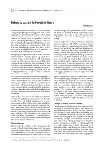
Introduction Gar-Gar, a crevasse of the Karun river is started in Shoushtar city and connects to Shotteit, another crevasse of the Karun in Band-e-Ghir. The Karun river is the biggest one in Iran[1]. Sedimentation and coastal destruction are two important phenomena about hydraulics of river; People living around rivers in coastal cities are influenced from these water basins[2]. Of course in the Gar-Gar, two factors cause to decrease sedimentation rate in coastline and then coastal destruction is decreased in coasts of this river. Knowing about methods and ways to protect coasts of river in ports and coastal cities, people would be safe from dangers due to flood and wetland progress into floodplain. Figure-1shows a map of Shoushtar area in which the Karun river is passing. At the bend, the hydraulic structure called Band Mizzan (meaning a gate which the water flow can be adjusted) is built at the meander of the Karun river near the center of Shoushtar city as a crevasse channel.
Band Mizzan
Garggar river
Shadrvan dam-bridge Karoon river
Garggar dam-bridge
Figure-1 A map of the area with Karun river and its branch GarGar passing the Shoushtar city. Band Mizzan which is at the branch is also shown.
TWO FUNDAMENTAL FACTORS As it was mentioned before in this paper, two main and natural factors around the Gar-Gar which help to decrease sedimentation rate and o coastal destruction would be minimized much. First, the direct route of the water canal in Gar-Gar guarantees avoiding any meander for water flowing through it. By this, there wouldn ’t acceleration for water motion in Gar-Gar. Second, coastal walls in two sides of the gar-Gar river are made by rock and stone. In fact, rocky walls in two sides of it are fasten to resist against water currents[3]. Therefore sedimentation in coastlines would be minimized as much possible. Figure-2 and Figure-3 show stone walls around the Gar-Gar in Shoushtar domain and direct route of it, respectively.
published by knowclub.com
WAC2007
Figure-2 Stone and rocky walls of the Gar-Gar
Figure-3 Route of the Gar-Gar canal straightly
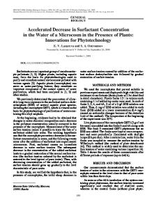
DATA ANALYSIS Measurements in the Gar-Gar river, Shoushtar domain, were done in 2002, 1003, 2004 and 2007 for deby of coastal sedimentation[1]. Deby values in coasts of the Gar-Gar has been studied. Water currents flowing through the river canal transport sediment particles to coastlines. Of course sedimentation so coastal destruction is decreased for Gar-Gar due to not existence meander and with rocky walls. Figure- 4(a, b, c & d) shows illustrate sedimentation deby variation during year months in 2002, 2003, 2004 and 2007.
published by knowclub.com
WAC2007
Coas tal de by var iation 2007
Coas tal de by var iat ion 2002 150
Sed.Deby
S e d .D e b y
150 100 50 0 1
2
3
4
5
6
7
8
9
10
11
100 50 0
12
1
2
3
100
S e d .D e b y
Sed.Deby
150 50 0 2
3
4
6
5
6
7
8
9
10
11
12
Coas tal de by var iation 2004
Coastal deby variation 2003
1
4
M onths
M ont hs
7
8
9
11
12
100 80 60 40 20 0 1
2
3
Months
4
5
6
7
9
10
11
12
M onths
Figure-4 ( a, b, c & d, left to righe; top to down) Sedimentation rate in months for 2002, 2003, 2004 and 2007
Concentrating on the diagrams we could get applied results. Using the applied results mentioned a below, hydraulics and hydrological principles important in water structures have been acquired in civil engineering. Shore protection and coast management is a basic and useful in ports and coastal cities. However we should be able to apply basins of surface water in life in optimum and efficient ways[4]. Surface water on the earth and atmosphere are two components of the double system important for weather change [5]. Currents flooding in river could be an important factor of coastal destroy and erode coastline. In fact, bend of a river is taken account a risk for route of it. So we must optimize coast protection avoiding coastal destruction. Figure-5 shows the pattern of surface and body currents for the Shotteit, the other branch of the Karun river in Shoushtar. This simulation was acquired of a software named LK12. Circular currents are seen flowig through the river.
Figure-5 Current Pattern in bend of the Shotteit
published by knowclub.com
WAC2007 According to below formula and following V, velocity of the river currents in environment of a circular rout with radius r, vortex of the current would be acquired. That is a vortex force w, is applied on the circular rout of river in bending of it. In Shotteit because of not existing any bending or circular direction, there wouldn’t be vortex force due to centrifugal force. V=W*r (1) Simulation of time-average flow could be more successful, with good agreement between simulated horizontal velocity components and those measured by ADCP (photo) and fair agreement for vertical velocity. The simulations could therefore be used to visualise, describe, and interpret the 3-D flow field in each bend, on the basis of >105 grid cells rather than <100 measurement points. In fact using acoustic Doppler current profiler it could be easy to simulate currents flowig in different depths of a river and finally we could prepare a good, correct and resolated map of the current in the river.
CONCLUSION AND DISCUSSION River basins as secondary water bodies canal are among lands. If lands around rivers would be stable without slip and river direction is straight, sedimentation rate in coasts of river will be the most little. River basin under conditions that there wouldn ’t be floodplain, flood so sedimentation wont be considerable. According to the deby profiles, we could see maximum sedimentation deby in March. It is resulted from maximum fall so more water body in canal then. The most important factors for decreasing sedimentation rate in river basin are as below: 1- Little water body flowing in river canal 2- Fastened walls in both sides of river 3- Srtaight direction of the canal without considerable curvature 4- Land stability around river without slipping
REFERENCES [1]Alleyassin A. 1995. Application of river engineering, Iran. [2[Mosaddad S.M. and Akhyani M. 2007. Coastal destroy due to river bending and drift of sedimentation due to piers. In: Proc of the Hydropower2007 International conference, Kandy, Sri Lanka, 2007, pp121-126. [3]Mosaddad S.M., Akbari Bidokhti A.A.and Ezam 2008. Current modeling considering civil engineering problems building coastal walls. In: Proc of the Fluid Mechanics Asian congress, Daejeon, South Korea, 2008, pp 234-241. [4]Shames, H., (1999), Mechanics of Fluids, London, pp: 150-240. [5] Samuels, P. et al, (1889), Methodology for conveyance estimation in two-stage straight, slewed and meandering channels, 11p.
published by knowclub.com