Page 1 Bronx Community District 7 - Land Use One & Two Family ...
BYTES of the Big Apple. Created January 2017. VdanCordlandt. Plaarik. Waedavawn. Celaetetery. BX 12. E G U N H I L L R. BX 08. A VE. Williamsbridge. Oval. TER O M E A. M O S H O L U PK W Y. Maanaatkan. KINGSBRIDGE RD. MN 12. BRONX RIVER. A JO R D E E G A N E XP Y. G R A N D C O N CC. St. James. Park.
C. R. O. S. S. B. R. O. N. X. E. X p y. BX 06. Manhattan. MN 12. Claremont. Park. A N EXP Y. COURSE. A. 0. RIVER. N C. C O. A V E. JE R O M E. M A J O R D E EG A NEY. N D. G R A. W E B S T E R. A V E. E T 6 5 ST. HARLEM. R I V E R. Yankee. Stadium. B
Source: MapPLUTO TM V.16.2,. BYTES of the Big Apple. Created January 2017. Feet. 1,500. 750. MultiFamily Elevator. Industrial/Manufacturing. Open Space. All Others or No Data. BX 07. E. I. Manhattan. 8. 8. S. T. RIVER. MN 12. Y EXPY. GRAND C o N c o
Jersey. S T A T E N I S L. Is L A N D E X P v | C T O R Y B L V D. * S H O R E EX P Y. W EST S H. William T. Davis. Wildlife Refuge. D A VE. Ocean. Breeze. Park. R I C H M O N O. C H M O N D R D. H Y L A N B L V D. Latourette. Park. Freshkills Park.
Public Facilities & Institutions. Vacant Land. Source: MapPLUTO TM V.16.2,. BYTES of the Big Apple. Created January 2017. Feet. 6,600. MultiFamily Elevator. Industrial/Manufacturing. Open Space. All Others or No Data. 3,300. SI 02. Isle of. Meadows.
2015 NYCgov Poverty Measure by PUMA. This metric from the Mayor's Office for Economic Opportunity accounts for NYC's high cost of housing, as well as other costs of living and anti-poverty benefits. Land Use Category. % Lot. Area. # Lots. Click here
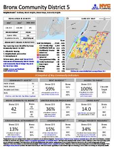
Square Miles. Population Density. 2.2. 41,590/sq mi. [. 0.5. Miles. 1Neighborhoods may be in multiple districts. Names and boundaries are not officially designated. 22000 US Census; 32010 US Census; 4American Community Survey 2011-2015 5-Year Estimat
B. R. O. N. X. K. ILL. Mill. Pond. Park. Franz. Sigel. Park. St. Mary's. Park. Randall's. Island Park. EAST 149 ST. EAST 149 ST. 3 AVBRIDGE. BR. OO. K. AV. GR. AN. D. CO. NC. O. UR. SE. EAST 140 ST. CY. PR. ESS A. V. EAST144 ST. EAST 136 ST. EAST 143
for Public Use Microdata Areas (PUMAs). PUMAs are geographic approximations of community districts. BX 2 shares PUMA 3710 with BX 1, and the ACS population estimate cannot be reliably disaggregated. 5NYC Dept of City Planning Facilites Database (2017
This metric from the Mayor's Office for Economic Opportunity accounts for NYC's high cost of housing, as well as other costs of living and anti-poverty benefits. Land Use Category. % Lot. Area. # Lots. Click here for a more detailed land use map of B
Street flooding. To learn more, please read Bronx CD 10's · Statements of Community District Needs · and Community Board Budget Requests · for Fiscal Year 2018. A Snapshot of Key Community Indicators. Website: www.nyc.gov/bronxcb10. Email: [email protected]
This metric from the Mayor's Office for Economic Opportunity accounts for NYC's high cost of housing, as well as other costs of living and anti-poverty benefits. Land Use Category. % Lot. Area. # Lots. Click here for a more detailed land use map of B
for Public Use Microdata Areas (PUMAs). PUMAs are geographic approximations of community districts. BX 3 shares PUMA 3705 with BX 6, and the ACS population estimate cannot be reliably disaggregated. 5NYC Dept of City Planning Facilites Database (2017
Square Miles. Population Density. 3.6. 31,453/sq mi. [. 0.5. Miles. 1Neighborhoods may be in multiple districts. Names and boundaries are not officially designated. 22000 US Census; 32010 US Census; 4American Community Survey 2011-2015 5-Year Estimat
Note: Census tracts and community district boundaries are not coterminous. Some census tracts span multiple community districts or park areas. For census tract data visit Census FactFinder at maps.nyc.gov/census. Community. District Boundary. 2010 Ce
South. Brother. Island. Rainey. Park. Soundview. Park. Tiffany. Street Pier. Barretto. Point Park. C o n cre te. P lan t P ark. Bronx. River. Parkway. North. Brother. Island. LAFAYETTE AV. HUNTS. PO. INT. AV. BARRETTO. ST. LONGWOOD. AV. BR. UC. KN. E
Crotona. Park. Tremont. Park. Sherman. Creek. Devoe. Park. St. James. Park. C lare m o n t. P ark. Bridge Park. Highbridge. Park. Harlem River Park. PRO. SPECT AV. OA. K. TR. EE. PL. EA. ST. 183 ST. HIG. H. BR. ID. GE. EA. ST. 181. ST. GRAND CONCOURS
RD. BRUCKN. ER. EX. PY. ST ANNSAV. TOW. NSEND AV. EA. ST. 174 ST. BR. ID. GE. BROOK AV. BROOK AV. CLA. REM. ON. T. PK. W. Y. W. ESTCH. EST. ER. AV. W. ESTCH. EST. ER. AV. TINTON AV. EA. ST. 16. 3ST. UNION AV. BRUCKN. ER. BLVD. BRYANTAV. BRUC. KN. ER.
DEMEYER ST. DELANOY AV. EAST 234 ST. MARION. AV. BRITTO. NST. ROMBOUTS AV. EAST 241 ST. EAST 243 ST. EAST 204 ST. PELHAM BRIDGE. YOUNG AV. EAST 210 ST. VIREO AV. CHESTER ST. HOLLAND AV. EAST 215 ST. VARIAN AV. DARK ST. EAST 239 ST. TILLOTSON AV. WOOD
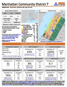
Page 1 ... E 79 St. MN. 11. Hudson. R iver. Central. Park. MN 9. MN. 10. MN 8. Manhattan Community District 7. Neighborhoods1: Lincoln Square, Manhattan Valley, Upper West Side. Top 3 pressing issues identified by. Manhattan Community Board 7 in 2017