Page 1 Staten Island Community District 2 - Land Use One & Two ...
Jersey. S T A T E N I S L. Is L A N D E X P v | C T O R Y B L V D. * S H O R E EX P Y. W EST S H. William T. Davis. Wildlife Refuge. D A VE. Ocean. Breeze. Park. R I C H M O N O. C H M O N D R D. H Y L A N B L V D. Latourette. Park. Freshkills Park. N E W DORP LN lin D. Roosevelt Beach. L O WE R N E W. Y O R K B A Y.
Public Facilities & Institutions. Vacant Land. Source: MapPLUTO TM V.16.2,. BYTES of the Big Apple. Created January 2017. Feet. 6,600. MultiFamily Elevator. Industrial/Manufacturing. Open Space. All Others or No Data. 3,300. SI 02. Isle of. Meadows.
TAPPEN. COURT. NETHERLAND. AV. LIBERTY AV. MILLSAV. PARK HILL AV. DALEMERE RD. COVENTRYRD. SIMONSON AV. ANJALI. LOOP. KINSEY PL. HODGES. PL. FREEDOM AV. VERA ST. GINA. COURT. MAPLE PKWY. GILESPL. KLONDIKE AV. THO. MPSO. N ST. GRASMERE DR. AYMAR AV. C
C. R. O. S. S. B. R. O. N. X. E. X p y. BX 06. Manhattan. MN 12. Claremont. Park. A N EXP Y. COURSE. A. 0. RIVER. N C. C O. A V E. JE R O M E. M A J O R D E EG A NEY. N D. G R A. W E B S T E R. A V E. E T 6 5 ST. HARLEM. R I V E R. Yankee. Stadium. B
for Public Use Microdata Areas (PUMAs). PUMAs are geographic approximations of community districts. 5NYC Dept of City Planning Facilites Database (2017); 6 Differences of less than 3 percentage points are not statistically meaningful. 7NYC Dept of Pa
22000 US Census; 32010 US Census; 4American Community Survey 2011-2015 5-Year Estimates, calculated for Public Use Microdata Areas (PUMAs). PUMAs are geographic approximations of community districts. 5NYC Dept of City Planning Facilites Database (201
LEEDS ST. CUBA AV. THOMAS ST. 8 ST. ISERNIA AV. LEXA PL. VERNON AV. CUNNINGHAMRD. CORBIN AV. NUGENT ST. HEINZ AV. DINTREE. LA. HARRISLA. TARRING ST. CLAWSON ST. BOW. ER. COURT. COTTER AV. WEST. SHO. REEXPY. BALTIMORE ST. AINSWORTH AV. CORTELYOU AV. B
BYTES of the Big Apple. Created January 2017. VdanCordlandt. Plaarik. Waedavawn. Celaetetery. BX 12. E G U N H I L L R. BX 08. A VE. Williamsbridge. Oval. TER O M E A. M O S H O L U PK W Y. Maanaatkan. KINGSBRIDGE RD. MN 12. BRONX RIVER. A JO R D E E
Source: MapPLUTO TM V.16.2,. BYTES of the Big Apple. Created January 2017. Feet. 1,500. 750. MultiFamily Elevator. Industrial/Manufacturing. Open Space. All Others or No Data. BX 07. E. I. Manhattan. 8. 8. S. T. RIVER. MN 12. Y EXPY. GRAND C o N c o
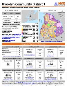
Citywide. Target. 85%. H ylan Blvd. M ain St. M an o r R d. Richm ond Rd. RocklandAv. H u gu en o t A v. Am boy Rd. ArthurKillRd. Richm ond Hill Rd. R ich m o.
Page 1 of 11. MANABESHIMA ISLAND JAPAN: ONE. ISLAND, TWO MONTHS, ONE MINICAR,. SIXTY CRABS, EIGHTY BITES AND FIFTY. SHOTS OF SHOCHU BY FLORENT. CHAVOUET. DOWNLOAD EBOOK : MANABESHIMA ISLAND JAPAN: ONE ISLAND, TWO. MONTHS, ONE MINICAR, SIXTY CRABS, EI
for Public Use Microdata Areas (PUMAs). PUMAs are geographic approximations of community districts. 5NYC Dept of City Planning Facilites Database (2017); 6 Differences of less than 3 percentage points are not statistically meaningful. 7NYC Dept of Pa
for Public Use Microdata Areas (PUMAs). PUMAs are geographic approximations of community districts. BX 2 shares PUMA 3710 with BX 1, and the ACS population estimate cannot be reliably disaggregated. 5NYC Dept of City Planning Facilites Database (2017
Drugs, Alcohol, Your Teen & You. The effects of youth substance abuse are devastating for our youth, parents, families and community. The well-being and future of our children are at stake. Take action! The Sisterhood, led by NYSNA RNs, will present
for Public Use Microdata Areas (PUMAs). PUMAs are geographic approximations of community districts. MN 2 shares PUMA 3810 with MN 1, and the ACS population estimate cannot be reliably disaggregated. 5NYC Dept of City Planning Facilites Database (2017
for Public Use Microdata Areas (PUMAs). PUMAs are geographic approximations of community districts. 5NYC Dept of City Planning Facilites Database (2017); 6 Differences of less than 3 percentage points are not statistically meaningful. 7NYC Dept of Pa
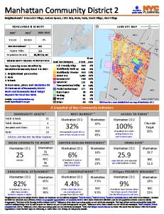
Square Miles. Population Density. 2.2. 41,590/sq mi. [. 0.5. Miles. 1Neighborhoods may be in multiple districts. Names and boundaries are not officially designated. 22000 US Census; 32010 US Census; 4American Community Survey 2011-2015 5-Year Estimat
of residents 5 years or older have limited · English proficiency. Queens. 18%. 20%. NYC. 21%. Queens CD 1 of residents have incomes below the NYCgov poverty threshold. See the federal poverty rate here. NYCgov POVERTY MEASURE11. Queens. 30%. 43%. NYC
for Public Use Microdata Areas (PUMAs). PUMAs are geographic approximations of community districts. MN 1 shares PUMA 3810 with MN 2, and the ACS population estimate cannot be reliably disaggregated. 5NYC Dept of City Planning Facilites Database (2017
Sign in. Page. 1. /. 2. Loading⦠Page 1. Page 2 of 2. Eacb1567b148a94cb2dd5d612c7b769256279ca60_Q8633_R329927_D1856546.pdf. Eacb1567b148a94cb2dd5d612c7b769256279ca60_Q8633_R329927_D1856546.pdf. Open. Extract. Open with. Sign In. Main menu. Displayi
JEWEL ST. 61 ST. 54. RD. 63 ST. ECKFORD ST. 58. RD. 60 ST. 72 ST. 35 ST. 53. RD. 57. RD. 59 PL. 34 ST. 54 ST. 48 ST. 34 ST. RUSSELL ST. NEWEL ST. DIAMOND ST. 55. AV. DUPO. N. T. ST. 62 DR. STEINW. AY ST. 61 RD. LO. MBARDY. ST. OLD. LA. 62 RD. 37. RD.
B. R. O. N. X. K. ILL. Mill. Pond. Park. Franz. Sigel. Park. St. Mary's. Park. Randall's. Island Park. EAST 149 ST. EAST 149 ST. 3 AVBRIDGE. BR. OO. K. AV. GR. AN. D. CO. NC. O. UR. SE. EAST 140 ST. CY. PR. ESS A. V. EAST144 ST. EAST 136 ST. EAST 143
South. Brother. Island. Rainey. Park. Soundview. Park. Tiffany. Street Pier. Barretto. Point Park. C o n cre te. P lan t P ark. Bronx. River. Parkway. North. Brother. Island. LAFAYETTE AV. HUNTS. PO. INT. AV. BARRETTO. ST. LONGWOOD. AV. BR. UC. KN. E